

My dad and I continued the tracing of our great
grandfather's path during the Revolutionary War a bit further. Our
plan was to go to the Washington Rock lookout post and to the Middlebrook Encampment. On our way I spotted an historical marker, so
we stopped at this site in Quibbletown even though we do not believe Isaac Anglin tread upon this land.
Quibbletown can be found within the Township of Piscataway, NJ. I knew
the history of Quibbletown from my days as the church clerk at Stelton Baptist
Church in Edison, NJ. Stelton Baptist
Church is the second oldest Baptist Church in New Jersey and the tenth oldest
in the United States. Early founders of
the church quibbled frequently over
which day of the week should be considered the sabbath day; Saturday or Sunday. A
portion of the congregation withdrew from that church and formed a separate
congregation, observing the seventh day as the Sabbath and organized a Seventh
Day Baptist Church with eighteen members in April of 1707.
But back to our Revolutionary War journey…
QUIBBLETOWN
 |
| 1777 Skirmishes |
Quibbletown was the site of numerous skirmishes in what was
called the Forage Wars where irregular military forces attempted to
procure whatever supplies were needed by whatever means were necessary to take
the supplies. The largest battle occurred on February 8,
1777, under the command of British General Charles Lord Cornwallis. The local Patriot militia was led by Colonel
Charles Scott and a separate militia commanded by Brigadier General Nathaniel
Warner. The Americans refused to
directly engage with the foraging party but attacked the flanks and rear as the
British retreated to New Brunswick. By
the end of June 1777, there were few citizens left in New Jersey who sympathized with the British due to the
constant raids and abuse of local citizens.
 |
| Quibbletown in the 1700s |
It was interesting to read about the lay of the land during
the time of these skirmishes. The plot
of land where the historic marker and cannons stood was once an island. Now, there is only a stream on one side
where the mill once stood. Having to access this land primarily by boat was
certainly a factor in Revolutionary wartime strategy.
 |
| John Graves Simcoe |


The Grasshopper was the nickname for a cannon used by the British in the late 18th century as a light battalion gun to support infantry. It was designed for service in rough terrain such as the frontiers of North America.
WASHINGTON ROCK
Continuing on with our day, the next stop was at Washington Rock State Park, situated on top of a ridge in the Watchung Mountains in what is now Green Brook Township, NJ. |
| Washington Rock |
In December of 1776, General William Woodford’s Virginia Brigade was ordered to join General George Washington and the Continental Army in New Jersey and became part of the Virginia Line of the Continental Army. This is the brigade that Isaac Anglin's regiment was a part of. Isaac probably served in some respect at this lookout point, situated less than 5 miles from the Encampment at Middlebrook.
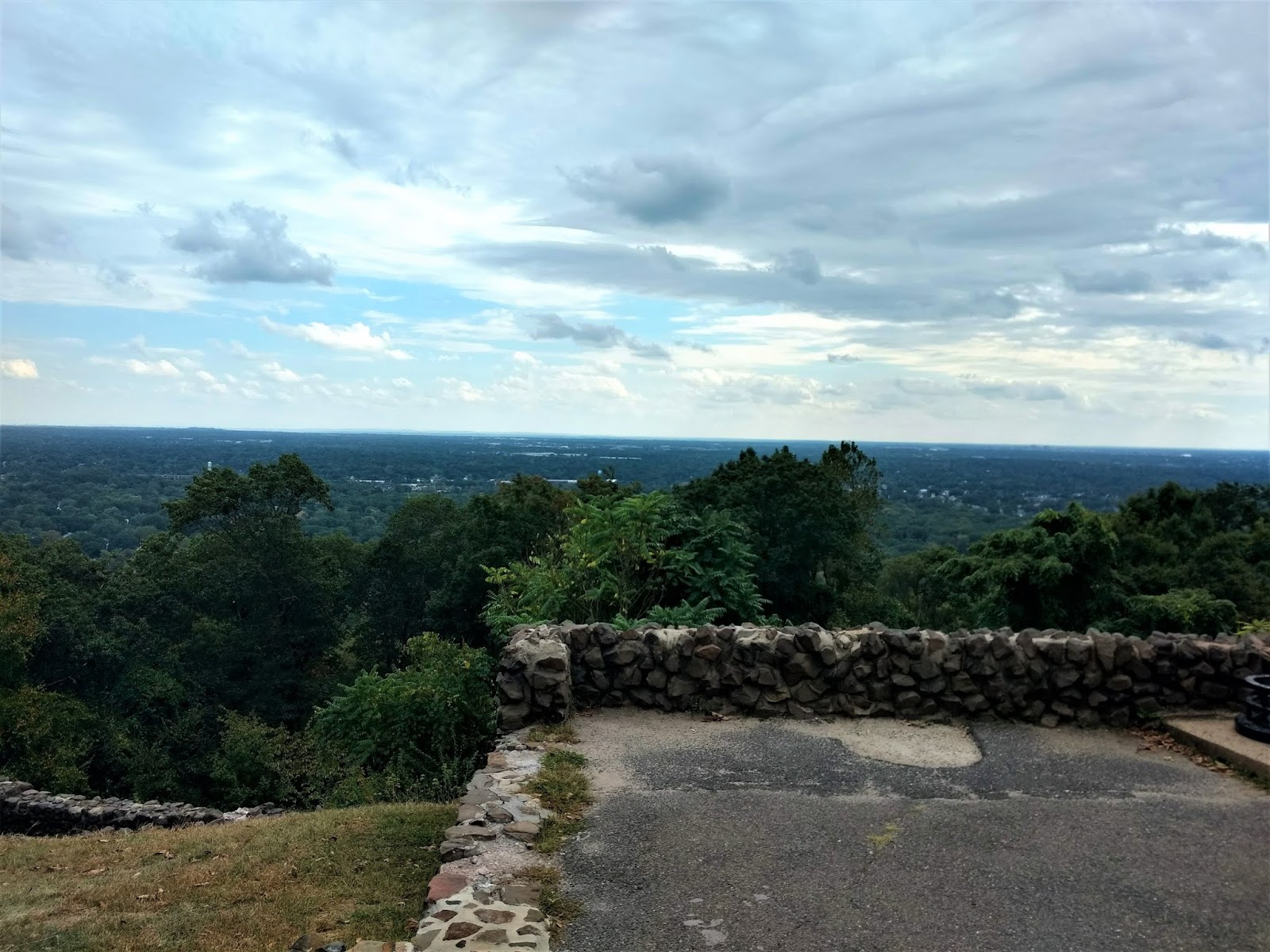
The strategic location of Washington Rock made it a valuable lookout point during the American Revolution for General Washington in June of 1777 when the British army under General William Howe was moving toward Westfield. From the vantage point of this natural rock outcropping, General Washington had a thirty-mile panoramic view of the valley. From here he was able to instruct his troops to circle behind Howe’s troops and cut off their retreat. It was a local resident by the name of Edward Fitz Randolph who guided General Washington to this location in June of 1777.
As we stood at the edge of this vista, we could imagine the incredible landscape that Washington and his men took in before pollution marred the skies. It is reported that they could see over to Staten Island, NY.


 |
| Washington Rock Monument |
MIDDLEBROOK ENCAMPMENT
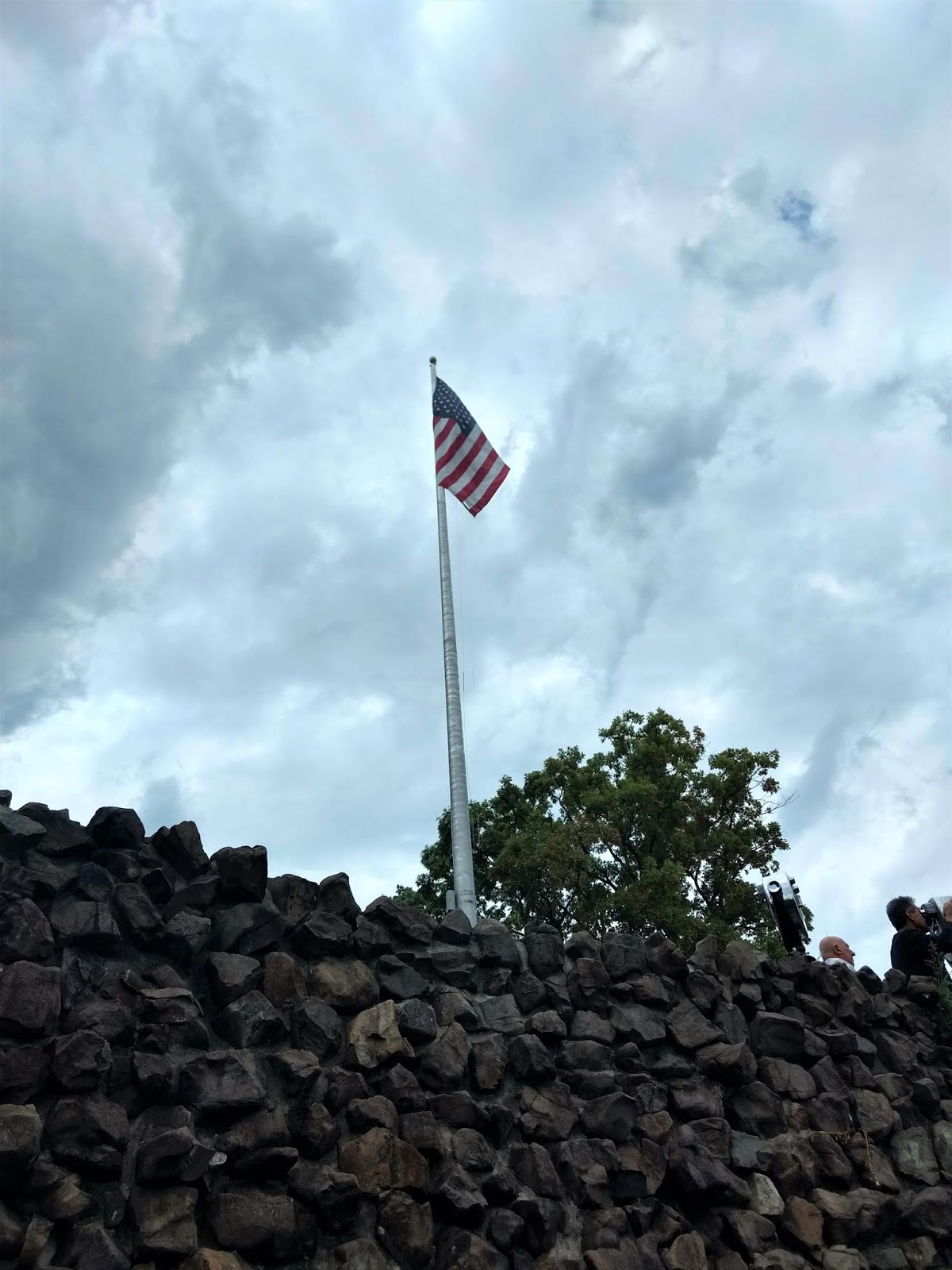
 Our next stop was the Middlebrook Encampment area, located about 4.5 miles from Washington Rock lookout point, in what is now Bridgewater, NJ. This was not an easy spot to find, even using a GPS. In fact, we nearly drove right past it but I spied the historical marker out of the corner of my eye. Unlike many historic locations, this spot remains very much like it must have looked 250 years ago. There is no paved parking lot and no one else was there, but once we got our bearings, you cannot miss the 13 star flag flying in all its glory.
 I have to wonder what Isaac might have thought when they reached this first ridge of the Watchung Mountains. Certainly to those of us who live in New Jersey, the Watchungs truly look like mountains, but to a mountaineer who was from Greenbriar County, (West) Virginia, these mountains may have appeared to be mere hills! Isaac and the Virginia troops were camped just west of the gap where Middlebrook creek flows out of the mountains, at Chimney Rock along today's Foothill Road. They were stationed here from May 28, 1777 until July 2, 1777.
As of May 20, 1777, Major General Woodford (whose brigade was at the Middlebrook Encampment and was the officer who signed Isaac's discharge papers), had two Brigadier Generals under him in New Jersey. General Stephen was in command of the 3rd, 7th, 11th & 15th Virginia Regiments and General Scott had the 4th, 8th, 12th & 16th Virginia Regiments. The 8th Regiment (Isaac's) was under Colonel Beauman and had 157 men.

The 13 Star Flag

 During the Revolutionary War, numerous flag designs were used. After the Declaration of Independence was signed on 4 July 1776, we realized we needed one flag to replace the assortment of flags used previously. Although legend has it that Betsy Ross sewed the first flag from a design by George Washington, this has not been substantiated. This 13-Star Flag became the Official United States Flag on June 14th, 1777 and is the result of the congressional action that took place on that date. Evidence points to Congressman Francis Hopkinson as the person responsible for its design. The first location this flag was flown was over continental troops was here at Middlebrook. The only President to serve under this flag was George Washington (1789-1797). This Flag was to last as our official flag for a period of 18 years.
This parcel of land was donated to the Washington Camp Ground Association with the condition that the Declaration of Independence be read every 4th of July and that a meeting should be held each year around George Washington's birthday, February 22.
It gave me such an incredible feeling in my heart and soul to know that our ancestor saw the first official flag for the United States fly above his camp. God bless you, Isaac Anglin, and all of those who dedicated their lives to ensuring our freedom!


I started doing a little more research after I posted the above blog and came upon some additional details. Below are two maps - the first map is a copy of the original map done by Captain Scull/Snell a cartographer in the 11th Pennsylvania Regiment. He joined Robert Erskine's geographers department in 1778. Erskine was Washington's map maker. This shows the area of the encampment and the roads that went from Middlebrook to Quibbletown, coincidentally, where my dad's and my journey began. You can click on each map to enlarge them.


There are two very good web pages from a local historian that give more details about Middlebrook and the Washington Campground Association:
http://www.donsnotes.com/middlebrook-encampment/mdlbrk-qbltwn-map.html
http://www.donsnotes.com/middlebrook-encampment/washington-campground-association.html
My dad also came upon details that tell us elements of the 11th & 12th Virginia Regiments & a company of the 8th Virginia Regiment participated in the Battle of Short Hills. There were several battles fought that took place on June 26, 1777 between Westfield and Metuchen in what is now Edison, NJ. I guess we will try to find out if Isaac was part of the crew that took part in this battle.
Additionally, my dad found this notation of Isaac Anglin's division being encamped for a short time at Jockey Hollow, near Morristown, NJ. Washington and his troops camped here during the harshest winter of the War, from December 1779 to June 1780.
 |
| "The Uncertain Revolution" by John T. Cunningham. |
The above activity in New Jersey is in additional to the Battle of Monmouth June 28, 1778.
______________
Our day ended with a stop at a East Jersey Olde Towne which my dad and
Comments
Post a Comment